Hydrography & Oceanography Survey Equipment
준설, 항만 유지관리, 내수면 측량, 해양 구조물 시공, 환경 조사처럼 수심과 해저 지형 정보가 중요한 현장에서는 장비 선택이 곧 데이터 품질과 작업 효율로 이어집니다. 측정 목적에 맞는 Hydrography & Oceanography Survey Equipment를 고르면 단순 수심 확인부터 고밀도 해저 지형 취득까지 업무 범위에 맞는 조사 체계를 구성할 수 있습니다.
이 카테고리는 휴대형 수심 측정기, 듀얼 채널 에코 사운더, 멀티빔 에코사운더처럼 수로측량과 해양 조사에 쓰이는 대표 장비군을 폭넓게 다룹니다. 현장에서는 선박 규모, 목표 수심, 요구 정밀도, 데이터 처리 방식이 모두 다르기 때문에, 장비의 등급과 운용 방식 차이를 함께 이해하는 것이 중요합니다.
수로·해양 조사 장비가 필요한 업무 범위
현장의 요구는 생각보다 다양합니다. 어떤 프로젝트는 특정 지점의 수심을 빠르게 확인하는 수준이면 충분하지만, 다른 프로젝트는 항로 단면 관리, 준설 물량 산정, 공사 전후 비교, 해저면 형상 분석처럼 연속적인 데이터 취득과 정리까지 필요합니다.
이런 이유로 수심 측정 장비는 단순 휴대형 장비와 조사용 에코 사운더, 그리고 넓은 폭으로 해저를 스캔하는 멀티빔 장비로 나뉘어 검토되는 경우가 많습니다. 보다 넓은 측위·항법 구성까지 고려한다면 속도 센서 같은 인접 장비도 함께 살펴보는 것이 자연스럽습니다.
간단한 수심 확인부터 정밀 해저 매핑까지
조사 목적에 따라 적합한 장비군은 크게 달라집니다. 소형 선박, 저수지 점검, 하천 수심 확인, 양식장 주변 점검처럼 빠른 확인이 우선인 경우에는 복잡한 조사 시스템보다 휴대성과 설치 편의성이 높은 장비가 더 실용적일 수 있습니다.
반대로 항만, 수로, 준설 현장, 수리 구조물 설계·시공 지원처럼 더 체계적인 조사가 필요한 경우에는 에코 사운더 계열이 중심이 됩니다. 특히 단일 지점 수심이 아니라 선박 진행 경로 전반의 데이터를 확보해야 할 때는 화면 기반 운용, 데이터 출력, 외부 장비 연동 여부가 중요해집니다.
여기서 한 단계 더 나아가 해저를 선 아래 한 줄이 아니라 폭 방향으로 고밀도 취득해야 한다면 멀티빔 에코사운더가 적합합니다. 이런 차이는 최종적으로 조사 속도, 커버리지, 후처리 결과물의 해상도에 직접적인 영향을 줍니다.
대표 장비 예시와 활용 방향
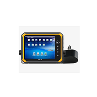
Hondex의 PS7F.L 수심 측정기는 비교적 간단한 수심 확인 업무를 염두에 둘 때 이해하기 쉬운 예입니다. 0.6~80m 범위의 측정이 가능하고 휴대형 운용 성격이 강해, 현장에서 포인트 점검이나 기초적인 수심 확인이 필요한 경우에 적합한 방향성을 보여줍니다.
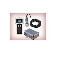
SATLAB HydroBeam S2는 듀얼 채널 에코 사운더로, 보다 전문적인 조사 워크플로우에 맞는 구성을 생각할 때 참고할 만합니다. 다양한 인터페이스와 표준 데이터 출력 포맷을 지원하는 점은 측위 장비나 기록 소프트웨어와의 연계를 고려하는 조사팀에 의미가 있습니다.
더 높은 밀도의 해저 데이터가 필요한 경우에는 R2sonic Sonic 2022V plus 멀티빔 에코사운더가 대표적입니다. 이 등급의 장비는 단순히 깊이를 재는 수준을 넘어, 넓은 조사폭과 고해상도 sounding 확보를 통해 해저 형상 파악과 정밀 수로측량 업무에 적합한 구성을 제공합니다.
장비 선택 시 확인해야 할 핵심 기준
첫 번째는 측정 대상 수역과 목표 수심입니다. 하천, 호수, 저수지, 연안 얕은 수역은 설치 방식과 운용 조건이 다르고, 더 깊은 수역이나 복잡한 저질 조건에서는 주파수 선택과 센서 구성이 결과에 영향을 줄 수 있습니다. 따라서 단순히 최대 측정 범위만 보는 것보다 실제 작업 수역에서 필요한 성능을 기준으로 판단하는 편이 합리적입니다.
두 번째는 선박과 전원, 설치 공간 같은 운용 조건입니다. 소형 보트에 적합한 장비와 조사선에 상시 탑재하는 장비는 요구 조건이 다르며, 장비 크기, 무게, 케이블 구성, 화면 운용 방식도 실사용 편의성에 영향을 줍니다. 현장에서 반복적으로 설치·철거해야 한다면 휴대성과 배선 단순성도 중요한 선택 요소입니다.
세 번째는 데이터 활용 목적입니다. 단순 확인용이라면 현장 판독성이 우선이지만, 보고서 작성, 단면 분석, 준설량 계산, 해저면 모델링까지 이어질 경우에는 출력 형식, 외부 장비 연동, 후처리 호환성을 함께 검토해야 합니다. 경우에 따라 선박 운동이나 항법 정보와의 연계가 필요하므로 Doppler Radar 같은 주변 시스템 검토도 이어질 수 있습니다.
주요 적용 분야
이 카테고리의 장비는 해양 분야에만 국한되지 않습니다. 하천·호소 수심 조사, 항만 접안 구역 점검, 준설 지원, 교량 및 댐 주변 점검, 연안 공학 조사, 수중 탐색 업무 등 다양한 환경에서 활용됩니다.
특히 공공기관, 엔지니어링사, 측량사, 해양 시공사 입장에서는 프로젝트별 요구 수준이 다르기 때문에 장비를 업무 등급별로 구분해서 접근하는 것이 유리합니다. 간단한 포인트 수심 측정, 연속적인 단일/듀얼 채널 조사, 고밀도 멀티빔 취득은 서로 대체 관계라기보다 목적이 다른 조사 방식에 가깝습니다.
또한 실제 현장에서는 조사 장비만으로 작업이 끝나지 않는 경우가 많습니다. 선박 간 또는 현장팀 간 협업이 필요한 작업에서는 워키토키 같은 통신 장비도 함께 고려되어 운영 효율을 높일 수 있습니다.
B2B 구매 관점에서의 검토 포인트
B2B 구매에서는 제품 스펙만 비교해서는 부족합니다. 반복 운용이 많은 조직이라면 설치 시간, 유지관리 편의성, 운반성, 작업자 숙련도, 데이터 정리 방식까지 포함해 판단해야 합니다. 장비가 현장 프로세스와 맞지 않으면 성능이 좋아도 실제 생산성은 기대에 못 미칠 수 있습니다.
예를 들어 간단한 현장 점검 위주라면 Hondex PS7F.L 같은 휴대형 성격의 장비가 효율적일 수 있고, 조사 보고서와 데이터 기록이 중요한 프로젝트라면 SATLAB HydroBeam S2 같은 조사형 장비가 더 적합할 수 있습니다. 정밀 해저 지형 취득과 넓은 커버리지가 핵심이라면 R2sonic Sonic 2022V plus 같은 멀티빔 장비를 검토하는 방식이 자연스럽습니다.
결국 중요한 것은 장비 등급과 프로젝트 요구 수준을 맞추는 일입니다. 단순 수심 확인, 표준 수로 조사, 고해상도 해저 매핑 중 어디에 초점을 두는지 명확해야 불필요한 과사양 또는 성능 부족을 줄일 수 있습니다.
업무 흐름에 맞는 장비 구성이 중요합니다
수로측량과 해양 조사는 같은 “수심 측정”으로 보이더라도 현장 목적에 따라 필요한 장비가 크게 달라집니다. 휴대형 수심 측정기, 듀얼 채널 에코 사운더, 멀티빔 에코사운더는 각각 다른 작업 범위와 데이터 깊이를 담당합니다.
이 카테고리는 그런 차이를 비교하고, 현장 조건에 맞는 조사 장비를 찾는 데 초점을 둡니다. 운용 수역, 필요한 데이터 수준, 설치 환경, 후처리 요구를 함께 검토하면 보다 현실적인 수로·해양 조사 장비 구성이 가능해집니다.
인증된 전문가에게 직접 연결